High water situations continue due to persistent rainfall across much of the state. As of about noon today, the line of rain mostly moves north and west, but more is on the way. A large line of rain, some heavy, will continue to park it over the Ohio River Valley through the next day or so. Otherwise, it’ll be cloudy and mild. Temperatures are running warmer by 10-15 degrees form yesterday. We sit in the mid and upper 40s but will likely warm into the 50s.
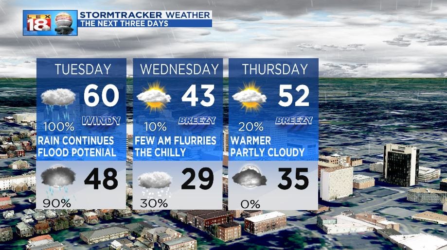
It’s been a gloomy day with overcast skies and mostly persistent rain or mist. The warmer air continues to pump into the region with a breezy southwesterly wind. Rain showers will continue with the southwesterly wind flow until a cold front changes things for a bit. The incoming warm front will boost us up into the 60s for afternoon highs tomorrow, before the subsequent cold front. That front will deliver heavy bouts of rain with the chance for a few rumbles of thunder as the main line passes. Then, cold air pours in. A few mix showers or flurries will fall across the state early Wednesday morning before all precipitation comes to an end. Cold air will filter in for a day as we drop back into the 40s Wednesday. The pattern repeats itself as we get to the end of the week.
The FLOOD WATCH remains in effect through Tuesday Afternoon. Watch for high water as rivers, streams, and creeks are all running high. Remember to NEVER drive through a flooded roadway.

