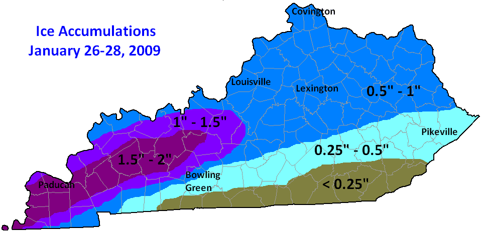
This weekend is the tenth anniversary of the 2009 ice storm that crippled Kentucky, southern Indiana, and northern Arkansas. It was a complex three days as freezing precipitation changed to sleet and snow, then back to freezing rain, then to a cold rain before ending as snow.

Timeline
Everything began as light freezing drizzle and freezing rain the night of Monday, January 26, 2009 across Kentucky. Across northern Kentucky the precipitation changed to sleet then snow through the night. By the next morning it was back to freezing rain for the Bluegrass while southern Kentucky dealt with rain. The warm wedge continued moving northward by Tuesday night. Rain, heavy at times down south, continued to fall. Some areas around Lake Cumberland received over four inches of rain during this event. Minor river flooding also occurred. Rain changed to snow from northwest to southeast on Wednesday morning. Three to four additional inches of snow was reported across northern Kentucky, less to the south.
Precipitation Amounts

Much of central Kentucky recorded up to an inch of ice during this three day event. Up to two inches of ice crippled western Kentucky. The ice weighed down and snapped trees and power lines.

Event snowfall totals from the Ohio River to the southern parkways ranged from almost nothing (mostly rain) to close to eight inches.
Impacts
The ice storm came almost exactly six years after the Bluegrass Ice Storm, when an inch and a quarter of ice covered cities like Lexington and Frankfort.

Governor Steve Behear claimed the 2009 ice storm was the biggest natural disaster the state had experienced in modern history. This event resulted in Kentucky’s largest power outage. 609,000 homes and businesses across the state were without power. It took up to ten days to restore power in Louisville. Widespread property damage from falling trees, large limbs, and line power lines occurred. This storm sadly claimed 24 lives.

